Finding My Way With a Smartphone
Updated Sept. 2016
At heart, I’m a map and compass person –

but there’s no denying some of the advantages GPS navigation has brought. I’m a late adopter of GPS technology and don’t have a lot of experience with actual GPS units, but for the past few years my iPod Touch, and now my Android smartphone, have been helping guide my way.
Hardware

While searching for an unlocked phone I came across the Asus Zenfone 2 ZE551ML Android smartphone. The 5.5″ size is larger than some may like, but for me it’s perfect and allows for more map detail. Other highlights include dual SIM card slots, Corning Gorilla Glass 3, a decent camera, and a micro SD card slot that allows up to 128GB cards. It also has a great built in GPS receiver. For an unlocked, quad core GSM smartphone running Android Lollipop, It was a bargain at $200 when I purchased it in the spring of 2016, but seems to have gone up in price a bit. This has become my do all replacement for my iPod, cell phone, and with the addition of a ZAGG Pocket foldable keyboard, even my laptop while bikepacking. Good cases are hard to find for this phone and the TUDIA OMNIX case, while not waterproof, has port covers, seems pretty rugged, and so far is the best option I’ve found.
A phone can only take so much and after a year and a half of hard use, including navigating the GDMBR, my Alaska travels, and seeing way to much snow and dampness this past winter, the display digitizer on my Asus died. I would have bought another one, but the new Motorola Moto G4 has better specs at a lower price. For $200 for 16GB or $230 for 32GB you get a universal unlocked smartphone compatible with all major U.S. carriers, in addition to most overseas carriers, not just GSM network carriers, running Android Marshmallow. For specs, it has an octa-core processor, 2GB of RAM, 5.5″ display, a pretty decent camera, and you can boost the storage another 128 GB with a microSD card, something you can’t do with an iPhone. After a few weeks of using the Moto G4, including navigating and photographing the second part of the XVT route, I’ll say it’s a noticeably faster than the Zenfone, especially browsing the internet, and the GPS seems much better in thick tree cover. Case options are pretty slim for this phone as well, but the Poetic Revolution case, while not Otter Box quality, seems to be the best one available right now. For a phone plan I use the AT&T GoPhone prepaid, no contract, $40 a month unlimited talk, text, and data plan, or the GoPhone pay per call plan, depending on my usage.
Prior to the smartphones, I used an iPod Touch, which is essentially and iPhone without a phone. I have a 5th generation model protected by an Otter Box case. Unfortunately the iPod Touch is also missing a built in GPS receiver. To remedy this I use an external, USB rechargeable, Dual Bluetooth GPS Receiver, which in my opinion works better than the built in GPS of the iPhone. The downside is it’s one more thing to carry and keep charged.
As for bike mounts, for the iPhone and smaller smartphones there’s a lot of choices, but for larger phablet sized phones, I haven’t found many that seem durable enough for off-road use. The Delta Hefty Holder is one mount that’s the exception.

Mine has survived the Great Divide Mountain Bike Route, as well as loads of singletrack riding, and has never ejected my phone. The locking latch is definitely the weak point, but if it breaks, the mount is still usable. The one downfall of the Heft Holder is it leaves the phone exposed to dirt and weather.
I found the Novara Nucleus Phone Holder on clearance at REI and while at first glance it seems like it won’t hold up, it’s proven to be durable this summer while bikepacking in Alaska and riding the XVT Bikepack Route.

Its never popped out of its mount, but as a precaution when the going gets rough, I clip one of the zipper-pulls to my Feedbag. This case has kept my phone dry in moderate rain and the part I really like is the phone clips into the mount in portrait or landscape mode, without any adjustments. The down side is the plastic window scratches pretty easy, but for the price I’m not complaining.
Charging:
Using the GPS functionality with the backlight set bright enough to see in the sun chews through some power, so to keep everything charged I use dynamo hubs on some of my bikes. My Surly Troll runs a Schmidt SON 28 ISO Disk and while it’s an expensive hub, it’s also the only dynamo to have a 5 year warranty.
While a great warranty doesn’t fix a broken part, it shows confidence by the manufacturer and to date, this hub has been flawless. I only wish Schmidt would design a better plug connector, the metric blade connectors are hard to find and have the appearance of a science project. Fortunately, as I learned from The Starving Cyclist, the Shimano dynamo female plug connector fits over and works with the male Schmidt blade connectors perfect.

My Raleigh Portage runs a cheep Shimano LX dynamo and by cheep, I mean $160 when I bought it new a few years ago, for the complete wheel with a Velocity Synergy 650b rim. While this bike doesn’t see the abuse of my touring bike, it probably sees more miles and in all sorts of weather. With quite a bit of plastic, the quality of the LX dynamo is not nearly as good as the Schmidt, but it does have a much better plug connector and so far has been problem free.
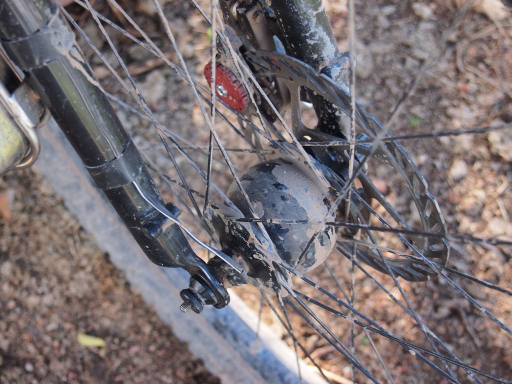
To get the power from the hub to the phone I use a Sinewave Cycles Revolution USB adapter. I originally used the Tout Terrain Plug, which lasted about 3 months and was replaced under warranty with a Plug II, but that only lasted about 6 months. The Revolution is fully sealed and waterproof, has a gold plated connector, reaches full power output at 9 MPH and so far it’s been problem free. I also prefer the mount anywhere design (I keep it in my top tube bag) over the stem cap mounting of Plug.
The one issue I did have was the phone cycling between a charging and discharging state during steep climbing, which is my fault for being slow and not a problem with the charger. To remedy this I run a Brunton Ember 2800 power pack in line between the USB adapter and the phone. The Brunton allows simultaneous charging and discharging, and acts as a buffer that allows the phone to continually charge regardless of speed. The Ember 2800 also has a built in solar panel, which is nice as a backup in case the dynamo fails in the middle of nowhere. To save power, I usually keep the phone in airplane mode, have only necessary apps running, and only turn the display on when I need to check directions. With this setup I’ve had no problem maintaining a 100% charge.
Unfortunately, not all of my bikes have dynamo hubs. I tried keeping my electronics charged with a solar panel while bikepacking on my Pugsley this past summer, but cloudy days and shaded trails produced meager results. I found carrying an extra USB power pack or two was about the same weight as the solar panel, more convenient, and easily got me through between charging sessions.
When I do get to a power outlet, I try to top up the charge on everything I carry. Outlet space is often rare in popular areas and nobody wants to be, or should be, that person who hogs two outlets with one giant charger. To keep the peace and get everything charged, I carry the necessary cables, including a 10-foot micro-USB cable, which make Instagraming away from an outlet much easier, and a 4-port USB charger. With 2.1 Amps per port, it’s enough to charge most anything, including tablets. As a side note, it’s a good idea to label your chargers, cables, and batteries to prevent someone from ending up with them by mistake.
Software
For maps I use a few different apps and options. MAPS.ME has been my go to app for most road navigation, including some pretty remote tracks.
The basemap is based on Open Street maps and while it lacks a lot of detail, it’s regularly updated, usually pretty accurate, and there are maps covering just about anywhere in the world. The main reason I use MAPS.ME is all maps are downloadable for offline use and when offline, the maps are fully zoomable and searchable. Tracks and waypoints can be imported as KML files, including GPX files which import after converting to KML with the free tool Gpx2kml. Nothing is perfect though and the one gripe I have with MAPS.ME is after updating the app, all the downloaded maps need to be updated as well to continue functioning. It’s a lesson I learned the hard way, with no WiFi or cell connection to fix the problem.
The other app based option I use is Gaia GPS. While it’s not as easy to use as MAPS.ME, the map choices and detail make this my go to app for backcountry navigation. Like MAPS.ME, maps can be downloaded for offline use, but you need to manually select the map area you would like to download. Tracks and waypoints can also be imported as either KML files or GPX files, without the need to convert.
For rough route planning I prefer paper maps, but when I need more detail or want to create a track, Google Earth is my go to.
When I’m trying to find a specific place, like an all you can eat Chinese Buffet, and WiFi or cell networks are available, I often use Google Maps as a guide. While there are a few different options to download Google Maps for offline use, I usually just take a screenshot for reference and switch to MAPS.ME for the navigation.
Digital Paper
There are times I need a map and a GPS version isn’t available, such as the SCT maps of Mexico. For maps such as these, I download them and keep them stored in a Dropbox folder I share with all my devices. Keep in mind, Dropbox contents are not stored offline on portable devices unless you manually select the document and enable the feature.
While I can’t precisely pinpoint my location, I can usually get a pretty good idea where I am by comparing the map to my MAPS.ME or Gaia GPS map and looking for obvious road curves, intersection, and other features.
For other maps, such as trail maps found at kiosks, or maps I can’t take with me, I just take a photograph.
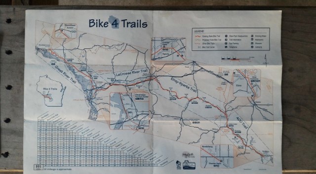
A picture is better than nothing and it often has details that the GPS basemaps lack. While perusing the website of Joe Cruz, I came across his review of the app Maplets. I’ve wished for an app that shows maps of local routes and trails for areas I travel through, and this is it. Maps are downloaded for offline use and many of the maps are GPS enabled to display your current location offline.
Route Planning
I’m not much of a detail planner, and this carries over to the routes I take. I usually have an idea as to where I want to go, but I tend to rely on the “ask a local” approach rather than detail planning a route with Google Earth or other software. For a great guide on planning and creating routes, I’m going to leave this to Scott Pauker, who is linking up dirt tracks from Alaska through South America and has a great post on his website, Spoke and Words. Also, Frank Revelo, a bike tourer and backpacker I met in Barstow, California a few years ago, has some great information as well on his site frankrevelo.com.

Gaia app has been great for me so far. It has been worth the 20 dollars.
Anyone tried the Garmin Topo Mexico SD card maps? $80 on the Garmin website.
For my Android smartphone (Moto X 2014 edition with 64GB builtin storage but no SD card slot, otherwise similar to your Asus, Otterbox case with plastic screen protector removed, stored in a foam RooCase most of the time), I use Maps.me and GaiaGPS like you, but also Here (Navteq maps) and Sygic (TomTom maps), both of which are free offline street mapping apps and sometimes have information that is not in the OSM street maps. I don’t have a dynohub, but I can get 10 days usage from the smartphone plus 2 x 6400mAh Anker external batteries (140g each), provided I keep screen brightness down and only access the smartphone when I need navigation assistance. Recording GPX tracks sucks smartphone battery rapidly.
I also bring along a Garmin Etrex 20, which can be bought at REI bundled with 1:100K maps for the entire US. That is what I would use if I wanted to record GPX tracks and that is normally my first choice for finding position information. 24 hours on 2 AA batteries. If I only turn it on when I need navigation assistance, the batteries will last weeks or even months. You can also download OpenCycleMapping topo maps (same as GaiaGPS uses) into a format that can then be loaded onto the Garmin Etrex 20 internal memory. I did this for maps for Greece. The procedure is described somewhere on the internet.
None of the above mentioned maps is fully accurate with respect to the dirt road network in the United States, nor are paper maps ever fully accurate either, nor can you rely on Google earth, since Google earth won’t show if a road is blocked by locked gates or not, nor whether there will be issues if you jump a locked gate.
Thanks Frank, this is some great information and I’m going to give Here and Sygic a try. As a note to others, Frank does some pretty remote desert touring, among other travels, and his site http://www.frankrevelo.com/ has a wealth of information.
Hey friend! So great to see another post from you after so long. You got me thinking about my overly electronically laden system and how to simplify. I’m on a lightening mission, again, after my broken frame incident in Guatemala, so I’m considering ways of ditching the laptop for a phone/keyboard combo. Problem is of course good photo editing and uploading of photos/text to website. I’ve been using a garmin Edge 810 since Alaska, cumbersomely creating routes on Google My Maps and converting them to GPX for the device. It works well because it’s a dedicated device to mapping so I don’t worry about the battery lasting the whole day, but requires a laptop or computer to download and convert the gpx files. I’ll have to look into that phone you got. One question: Why use the ipod touch with gps addition when you have that phone with gpx? Or are you saying you ditched the ipod when you got that phone? If that phone works well enough with gaia gps to really keep you running, you’ll keep me considering.
Looking forward to more posts when inspiration strikes you… about your Divide experience, and more. Sending big hugs your way from down South,
Scott
For a trip as long as yours, I couldn’t imagine traveling without a laptop. While my phone worked great for Instagram, the apps I’ve found don’t have the features I need for photo editing, especially for RAW images. The one plus I did find is the amount of time I saved not staring at the computer screen.
I replaced the iPod with the Asus phone before I left for the GDMBR. I was looking to consolidate my electronics to save space and weight and I was fine living without my laptop for a few months. After being mounted to my handlebars pretty much all summer, the phone’s proven to be pretty durable, although I’m not sure how it will fair in the hands of someone who’s broken two Surly frames.
I’m still amazed by Gypsy by Trade’s latest post and how little he carries. Lael probably has just a toothbrush and a pair of running shoes.
Safe travels to you my friend.