
If you haven’t read my previous posts, about the trip I took up the Great Divide Mountain Bike Route, you can read them here.
My stomach bug was still holding on when I rolled into Banff and honestly, the town is nothing like mountain town I expected it to be. The town of Banff is part of Banff National Park, so technically you need a park pass just to be there. Combine that with crowds of selfie stick toting tourists and I just wanted out. But before I was going anywhere, my bike needed some maintenance and I needed to resupply with food.
Bike Geek Side Note: The Chris King bottom bracket I was running was a little rough before I started the Divide, but I gave it a cleaning, greasing, and hoped for the best. Unfortunately with the rain and mud that plagued us in New Mexico, the bottom bracket was just about seized when I rolled into Steamboat Springs. After another cleaning and greasing it was “ready” for the second half of the GDMBR. The rain and mud returned when I crossed into Canada and once again things were seizing up. After no luck finding a decent Hollowtech II bottom bracket in Banff, I gave the King another cleaning and greasing. The the bearings were so worn the inner races fell out when the crankset was removed. Long story short, with two more cleanings and greasings along the way, it made it all the way back to Vermont. Impressive durability.
I really didn’t have a plan after finishing the GDMBR; I still had over a month before I wanted to be back in Vermont and figured I’d ride somewhere, but the where I didn’t know. The rain that followed me since crossing into Canada convinced me to head back to the States and the mud convinced me not to ride the GDMBR to get there – it was time for some pavement riding and hitchhiking. After a few hours grinding into a headwind along the Trans-Canada Highway I turned left onto the Kootenay Highway, made a cardboard sign, and waited for a ride.
The Kootenay Highway, also known as Highway 93, passes through Kootenay National Park, part of a UNESCO World Heritage Site, and is also part of the Adventure Cycling Great Parks Route. The scenery is beautiful, but it’s also the main link between Alberta and the Columbia Valley, so it has quite a bit of traffic.
I didn’t have to wait long before a Sprinter camper pulled over, with another truck loaded with mountain bikes and kayaks just behind. When I was handed a beer before any words were exchanged I knew this was going to be a great ride. Andrew and his family had been adventuring around Canada and to add a little more adventure to their trip, they decided to pick up a dirty bikepacking hippie.
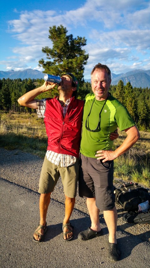
I couldn’t have asked for a better ride, they were heading back to Portland, OR and offered to drive me as far as I wanted to go. I wanted to stay in the mountains, so hopped out just south of Fort Steele, BC and rode pavement with a tailwind back to the border in Roosville.
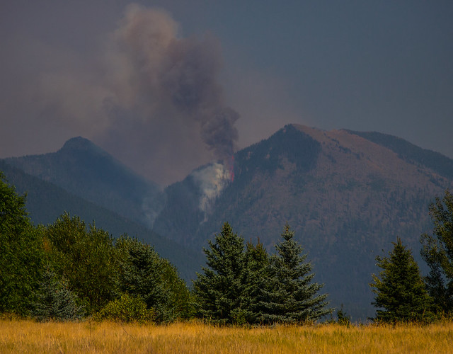
As I mentioned in my last Great Divide Mountain Bike Route post, when I got back to the U.S. I was greeted by forest fires, smoke and road closures. Both the Going-to-the-Sun road, which crosses Glacier National Park, and U.S. Route 2, which crosses to the south of the park, were both closed,

so I decided to link up still open parts of the GDMBR, forest roads, singletrack, and pavement over to Adventure Cycling headquarters in Missoula Montana to plan the rest of my trip.


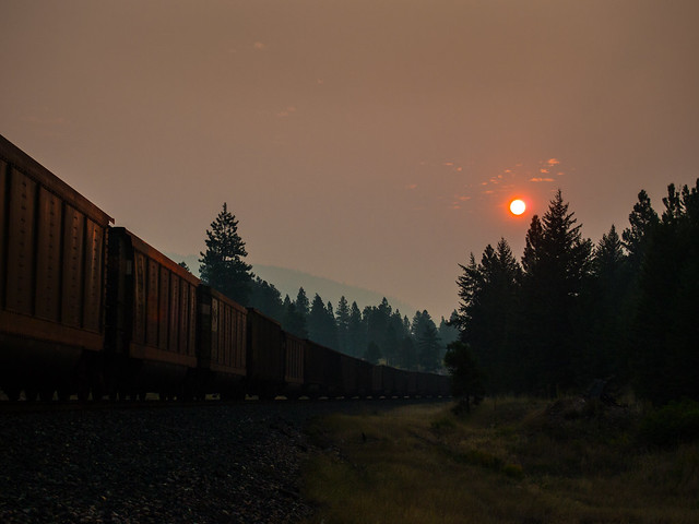
But there was no escaping the smoke and it seemed like much of the northwest was burning, so after talking with some of the Adventure Cycling staff and pouring over maps, I decided to ride back to Vermont. My plan was to loosely follow the Northern Tier Route using as many bicycle paths and dirt roads as reasonably possible. Heading east I had one more crossing of the Continental Divide,

then a whole lot of pavement riding to the North Dakota border. There’s not a lot of options for routes across Montana and the route I took, Highway 200, has a 80 mph speed limit and hardly any shoulder, but at least the traffic is light. Once I crossed into North Dakota and joined the Northern Tier Route the riding and the scenery improved.
This is also where I met Peter Limberg – snowboarder, photographer, and a wicked fun person to travel with.

He was riding from Oregon to Wisconsin, with a stop off in Minneapolis and was looking for a change of pace from all the highway biking he had been doing.

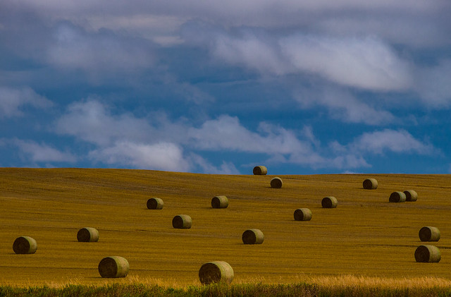
North Dakota was definitely a highlight of the trip and felt like a step back in time. We rode low traffic backroads, the people were unbelievably friendly, we camped in town parks without a hassle and most every driver was courteous.


When we entered Minnesota the Northern Tier Route headed north, but we decided to head south towards Fergus Falls for some laps around the local BMX track

and miles of rails-to-trails riding. In passing I heard mention of the Lake Wobegon Trail and being a fan of the NPR radio show A Prairie Home Companion, I wanted to ride it. What I didn’t know is the Central Lakes Trail connects to it from the west and it almost connects to the Mississippi River Trail in the east. Linking all this up, we were able to ride across much of Minnesota on gravel and paved bicycle paths, another trip highlight.


After parting ways with Peter in Minneapolis and taking almost a full day finding my way out of the Twin Cities, I headed to Wisconsin and continued linking up bike paths across the state. Wisconsin has some great paved and gravel routes and I linked up the Great River State Trail, La Crosse River State Trail, Elroy-Sparta State Trail, and the 400 Wisconsin State Trail for a total of 101 miles.


From Madison I took the Southwest Commuter Path and the Badger State Trail to the Illinois border, then the Jane Adams Trail to Freeport. When I rolled into town my bike needed some maintenance and the folks at Freeport Bicycle Co. offered me a work stand, tools, supplies, and all the time I needed to get it tuned up. They also helped me plot a route to Indiana that included the Illinois & Michigan Canal State Trail.
Indiana didn’t have any bicycle paths for me to travel on, but it did have plenty of roads laid out in a perfect grid, many of them gravel roads. When I wanted a change from the road I was on, there was usually another one paralleling it a mile or so away I could switch to.

Outside Fort Wayne I intersected with the Northern Tier Route again and followed it through Ohio,

Pennsylvania, and New York,

where I detoured north through the Adirondack Mountains

and finally crossed into Vermont.
Some notes from the trip:
- Eastern Montana, at least the route I took, has some of the worst tap water; if it didn’t smell like sulfur it tasted like iron.
- It’s also a long way between “towns” and very dry, so carrying extra water was needed
- North Dakota had some of the easiest free camping and we always camped under some sort of gazebo or shelter. Being polite and stealth worked every time.
- If you’re looking for drink and aren’t easily offended, Wet Spot Liquor at mile post 69 in Glen Ullin, ND can’t be missed. They don’t see outsiders very often.

- Riding most of the trails I used across Wisconsin requires a $5 a day trail pass, but lets just say I didn’t see anyone checking.
- The Elroy-Sparta State Trail has three tunnels. Put on your rain gear and dig out your headlamp, the tunnels are wet and dark.

- The Badger State Trail has one 1,200-foot long tunnel that curves inside, so you can’t see the exit from the entrance. It’s also wet and dark.
- The Illinois & Michigan Canal State Trail hasn’t been maintained in a few sections, so detours are needed.
- Once the Northern Tier Route starts traveling along Lake Erie, the ruralness ends and you have to be much more creative with your stealth camping.
- The Northern Tier Route follows the Erie Canalway Trail through New York for 85 miles, from Buffalo to a little east of Rochester.
- It took me about 5 weeks to go from Missoula, to where I live in northern Vermont.

Loved the whole story :D Great photos also :)
Fonty, geat photos as usual. How you make dull shot become eye candy is a mystery to me. Amazing.
Thanks, it’s definitely a compliment coming from you Dean. Honestly, many of these shots were taken with my phone and processed with the Earlybird filter on Instagram. I hang my head in shame now ;-)